Tropical Storm Ian formed on September 23rd, 2022 and tracked east across the Caribbean Sea for several days.
Ian strengthened into a hurricane early on September 26th. Ian began rapidly intensifying and twelve hours later became a category two storm with maximum sustained winds of 100 mph.
Early on September 27th, Hurricane Ian strengthened to a category three, major hurricane just prior to making landfall in western Cuba. Ian weakened slightly as it passed over Cuba.
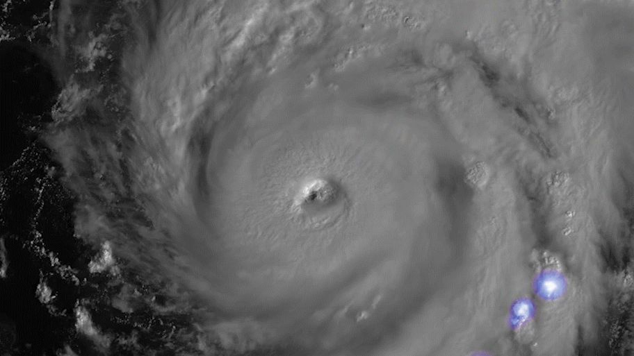
As Hurricane Ian re-entered open waters, this time over the Gulf of Mexico, the storm began quickly re-intensifying. In the morning of September 28th, Ian became a category four hurricane with maximum sustained winds of 155 mph.
Hurricane Ian made landfall in Cayo Costa, Florida as a category four storm with maximum sustained winds of 150 mph.
Visit the National Hurricane Center for updated information and forecasts on Hurricane Ian.
Satellite animations of this event:
Hover over the boxes to play. Click the images to view enlarged
Hurricane Ian's Full Journey
Description:
Hurricane Ian’s full journey across the Caribbean, through the Gulf of Mexico, and into the Southeast U.S.
Satellite: GOES-16
Product: GeoColor
Timespan: 09/23/2022 00:00 - 10/01/2022 00:10 UTC
Hurricane Ian Makes Landfall Near Georgetown, South Carolina
Description:
Hurricane Ian makes landfall near Georgetown, South Carolina as a category one storm.
Satellite: GOES-16
Product: Visible (band 2)
Timespan: 09/30/2022 16:00 - 09/30/2022 18:27 UTC
Hurricane Ian Approaches South Carolina and Second U.S. Landfall
Description:
As a category one storm, Hurricane Ian makes its approach to South Carolina and its second U.S. landfall.
Satellite: GOES-16
Product: Visible (band 2)
Timespan: 09/30/2022 12:00 - 09/30/2022 14:59 UTC
Ian Regains Hurricane Strength
Description:
Ian regains hurricane status off the coast of Florida.
Satellite: GOES-16
Product: GeoColor
Timespan: 09/29/2022 17:06 - 09/29/2022 21:01 UTC
Ian's Low Level Circulation Peeking Through
Description:
Ian’s low level circulation peaking through clouds above, as it moves north into the Atlantic Ocean.
Satellite: GOES-16
Product: Visible (band 2)
Timespan: 09/29/2022 15:00 - 09/29/2022 19:15 UTC
Ian Re-Emerges Over the Atlantic
Description:
After moving through Florida, Ian moves re-emerges over the Atlantic Ocean.
Satellite: GOES-16
Product: Geocolor
Timespan: 09/29/2022 11:01 - 09/29/2022 16:21 UTC
Hurricane Ian's Full Evolution Before and After its Florida Landfall
Description:
A high resolution view of Hurricane Ian’s full evolution before and after landfall in Florida.
Satellite: GOES-16
Product: Visible (band 2)
Timespan: 09/28/2022 12:00 - 09/28/2022 23:07 UTC
Hurricane Ian Landfalls in Cayo Costa, Florida
Description:
Hurricane Ian makes landfall in Cayo Costa, Florida as a category four storm.
Satellite: GOES-16
Timespan: 09/28/2022 17:38 - 09/28/2022 19:05 UTC
Extraordinary Amount of Lightning Surrounding Hurricane Ian's Eye
Description:
An extraordinary amount of lightning surrounding Hurricane Ian as it approaches landfall in Florida.
Satellite: GOES-16
Product: Visible (band 2), GLM Group Energy Density
Timespan: 09/28/2022 12:00 - 09/28/2022 16:01 UTC
Dangerous, Category Four Hurricane Ian Nears Florida
Description:
A dangerous, category four Hurricane Ian nears the Florida coastline.
Satellite: GOES-16
Product: GeoColor
Timespan: 09/28/2022 10:46 - 09/28/2022 13:11 UTC
Hurricane Ian Approaches Florida
Description:
The sun sets on Hurricane Ian as it continues its Florida approach.
Satellite: GOES-16
Product: GeoColor
Timespan: 09/27/2022 17:00 - 09/28/2022 01:20 UTC
Hurricane Ian's Full Day Evolution Over the Gulf of Mexico
Description:
A ten hour, high resolution time lapse of Hurricane Ian over the Gulf of Mexico.
Satellite: GOES-16
Product: Visible (band 2)
Timespan: 09/27/2022 12:00 - 09/27/2022 22:13 UTC
The Lightning within Hurricane Ian as it Treks over Gulf of Mexico
Description:
Lightning within Hurricane Ian as it tracks over the Gulf of Mexico.
Satellite: GOES-16
Product: Visible (band 2), GLM Group Energy Density
Timespan: 09/27/2022 14:25 - 09/27/2022 19:22 UTC
The Impressive, Clear Eye of Hurricane Ian
Description:
Hurricane Ian’s impressive and clear eye over the Gulf of Mexico.
Satellite: GOES-16
Product: Visible (band 2)
Timespan: 09/27/2022 15:30 - 09/27/2022 18:25 UTC
Hurricane Ian's Lightning-Packed Eye Wall
Description:
A powerful Hurricane Ian and its eye wall packed with lightning.
Satellite: GOES-16
Product: Visible (band 2), GLM Group Energy Density
Timespan: 09/27/2022 14:25 - 09/27/2022 16:12 UTC
Hurricane Ian's Eye Clears
Description:
Hurricane Ian eye clears out as it intensifies over the Gulf of Mexico.
Satellite: GOES-16
Product: Visible (band 2)
Timespan: 09/27/2022 13:00 - 09/27/2022 16:01 UTC
Hurricane Ian's Explosive Development Into A Major Hurricane
Description:
Hurricane Ian rapidly intensifying from a tropical storm to a major hurricane.
Satellite: GOES-16
Product: Infrared (band 11)
Timespan: 09/26/2022 01:30 - 09/27/2022 15:10 UTC
Hurricane Ian Becomes a Major Hurricane, Approaches on Cuba
Description:
Hurricane Ian strengthens to a category three hurricane with maximum sustained winds of 115 mph.
Satellite: GOES-16
Product: Infrared (band 11)
Timespan: 09/27/2022 04:23 - 09/27/2022 07:22 UTC
High Resolution, Thirty-Second Imagery of Hurricane Ian
Description:
A high resolution view of Hurricane Ian in the Caribbean.
Satellite: GOES-16
Product: Visible (band 2)
Timespan: 09/26/2022 17:36 - 09/26/2022 22:59 UTC
Sunset on Hurricane Ian as it Approaches Cuba
Description:
Hurricane Ian continues to track north as it approaches Cuba.
Satellite: GOES-16
Product: GeoColor
Timespan: 09/26/2022 15:30 - 09/26/2022 23:10 UTC
Hurricane Ian Strengthens to A Category Two Storm
Description:
Hurricane Ian strengthens to a category two storm as it approaches Cuba.
Satellite: GOES-16
Product: Infrared (band 11)
Timespan: 09/26/2022 08:01 - 09/26/2022 20:51 UTC
Hurricane Ian Tracks North in Caribbean
Description:
A strengthening Hurricane Ian tracks north in the Caribbean.
Satellite: GOES-16
Product: GeoColor
Timespan: 09/26/2022 15:36 - 09/26/2022 18:06 UTC
Hurricane Ian Intensifies in the Caribbean
Description:
Hurricane Ian approaches category two strength in the Caribbean Sea.
Satellite: GOES-16
Product: Visible (band 2)
Timespan: 09/26/2022 14:59 - 09/26/2022 16:38 UTC
Tropical Storm Ian Bubbling in the Caribbean Sea
Description:
A seven hour time lapse of Tropical Storm Ian’s convection bubbling in the Caribbean Sea.
Satellite: GOES-16
Product: Visible (band 2)
Timespan: 09/24/2022 15:00 - 09/24/2022 21:46 UTC
Tropical Storm Ian Slowly Organizing
Description:
Tropical Storm Ian slowly organizing and strengthening in the southern Caribbean Sea.
Satellite: GOES-16
Product: GeoColor, GLM Group Energy Density
Timespan: 09/24/2022 08:00 - 09/24/2022 14:50 UTC
Tropical Storm Ian Forms in the Southern Caribbean Sea
Description:
Convection within the newly-formed Tropical Storm Ian.
Satellite: GOES-16
Product: GeoColor, GLM Group Energy Density
Timespan: 09/23/2022 20:50 - 09/24/2022 01:40 UTC
Lightning and Convection within Tropical Depression Nine
Description:
The lightning and convection within Tropical Depression Nine, a developing system.
Satellite: GOES-16
Product: Visible (band 2), GLM Group Energy Density
Timespan: 09/23/2022 11:30 - 09/23/2022 13:44 UTC
Convection Fires In 98L
Description:
Deep convection fires within a tropical area of interest, 98L.
Satellite: GOES-16
Product: Infrared (band 11)
Timespan: 09/23/2022 04:00 - 09/23/2022 06:14 UTC
Low Level Circulation of 98L Exposed
Description:
An area of low-level circulation associated with 98L, peeking through the upper level clouds
Satellite: GOES-16
Product: Visible (band 2)
Timespan: 09/22/2022 16:49 - 09/22/2022 19:46 UTC
Tropical Wave Being Closely Monitored for Future Development
Satellite: GOES-16
Product: Visible (band 2), GLM Group Energy Density
Timespan: 09/20/2022 10:00 - 09/20/2022 14:40 UTC