As the fifth named storm of the 2021 Atlantic hurricane season, Tropical Storm Elsa formed on July 1st, 2021 around 900 miles east of the Windward Islands. After rapidly intensifying, Elsa became a hurricane peaking in intensity with maximum sustained winds of 85 mph. Elsa tracked northwest across the Caribbean Sea, bringing significant wind damage to numerous islands including Barbados, Dominican Republic, and Haiti. Early on July 5th, Tropical Storm Elsa made its first landfall in southwestern Cuba.
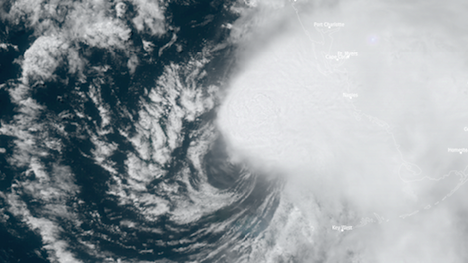
After re-emerging over water in the Gulf of Mexico, Tropical Storm Elsa made landfall in Taylor County, Florida on July 7th bringing tropical storm force winds and minor storm surge to the Florida coastline. Wind damage was relatively minor as Elsa’s strongest winds remained offshore
Over the next two days, Elsa maintained tropical storm strength as it moved northeast across the Southeast and Mid-Atlantic U.S. With Elsa came heavy rain that triggered flash floods in the New York City metro region and other parts of the Northeast.
A total of 14 deaths and an estimated 1.2 billion dollars of damage have been attributed to Hurricane Elsa
Satellite animations of this event:
Hover over the boxes to play. Click the images to view enlarged
Elsa Strengthens into a Hurricane
Description:
Elsa rapidly intensifies into a hurricane near the Windward Islands.
Satellite: GOES-16
Product: Visible (band 2), GLM Group Energy Density
Elsa Drifts North over Mid-Atlantic
Description:
The exposed low-level circulation of Tropical Storm Elsa drifting north over the Mid-Atlantic U.S.
Satellite: GOES-16
Product: Visible (band 2), GLM Group Energy Density
Elsa Makes Landfall, Pushes into Inland Florida
Description:
Tropical Storm Elsa makes landfall and pushes inland.
Satellite: GOES-16
Product: Visible (band 2), GLM Group Energy Density
Tropical Storm Elsa Makes Landfall in Florida
Description:
A broad view of Tropical Storm Elsa landfalling in Taylor County, Florida.
Satellite: GOES-16
Product: GeoColor
Elsa Skirts by Florida’s West Coast
Description:
Elsa’s exposed low-level circulation and offset convection skirt by Florida’s west coast.
Satellite: GOES-16
Product: GeoColor, GLM Group Energy Density
Evolution of Elsa over the Gulf of Mexico
Description:
A sunrise to sunset view of Elsa over the Gulf of Mexico, paralleling the Florida coastline.
Satellite: GOES-16
Product: Visible (band 2)
Tropical Storm Elsa Crosses Cuba
Description:
Tropical Storm Elsa landfalls in Cuba and re-emerges over the open waters of the Florida Straits.
Satellite: GOES-16
Product: GeoColor, GLM Group Energy Density
Elsa Forms, Tracks Towards Caribbean
Description:
A thirty hour time lapse of Elsa forming and strengthening into a hurricane.
Satellite: GOES-16
Product: Infrared (band 11)