Reykjanes Peninsula Volcanic Eruptions

During the night of December 18, 2023, the long-awaited eruption of a volcanic system on the Reykjanes Peninsula occurred as a fissure tore open the ground near the town of Grindavik, Iceland. Lava and smoke spewed out of the molten crevice in a fiery spectacle.

Over a month earlier in November, residents of the town of Grindavik were evacuated as a precaution following thousands of earthquakes and tremors hinting at the upcoming eruption.

Only a few weeks after the first eruption on the morning of January 14, 2024, another fissure opened up in the Earth in the same vicinity as the previous one following an increase in seismic activity, lasting nearly two days.

Less than a month later during the early morning hours of February 8, yet again a volcanic eruption ripped wide the Earth, unleashing lava from the igneous world below.

On the night of March 16th, once more a maw tore open on the surface near Grindavik, unleashing the most powerful eruption to date and reddening the skies of the Icelandic capital of Reykjavik.
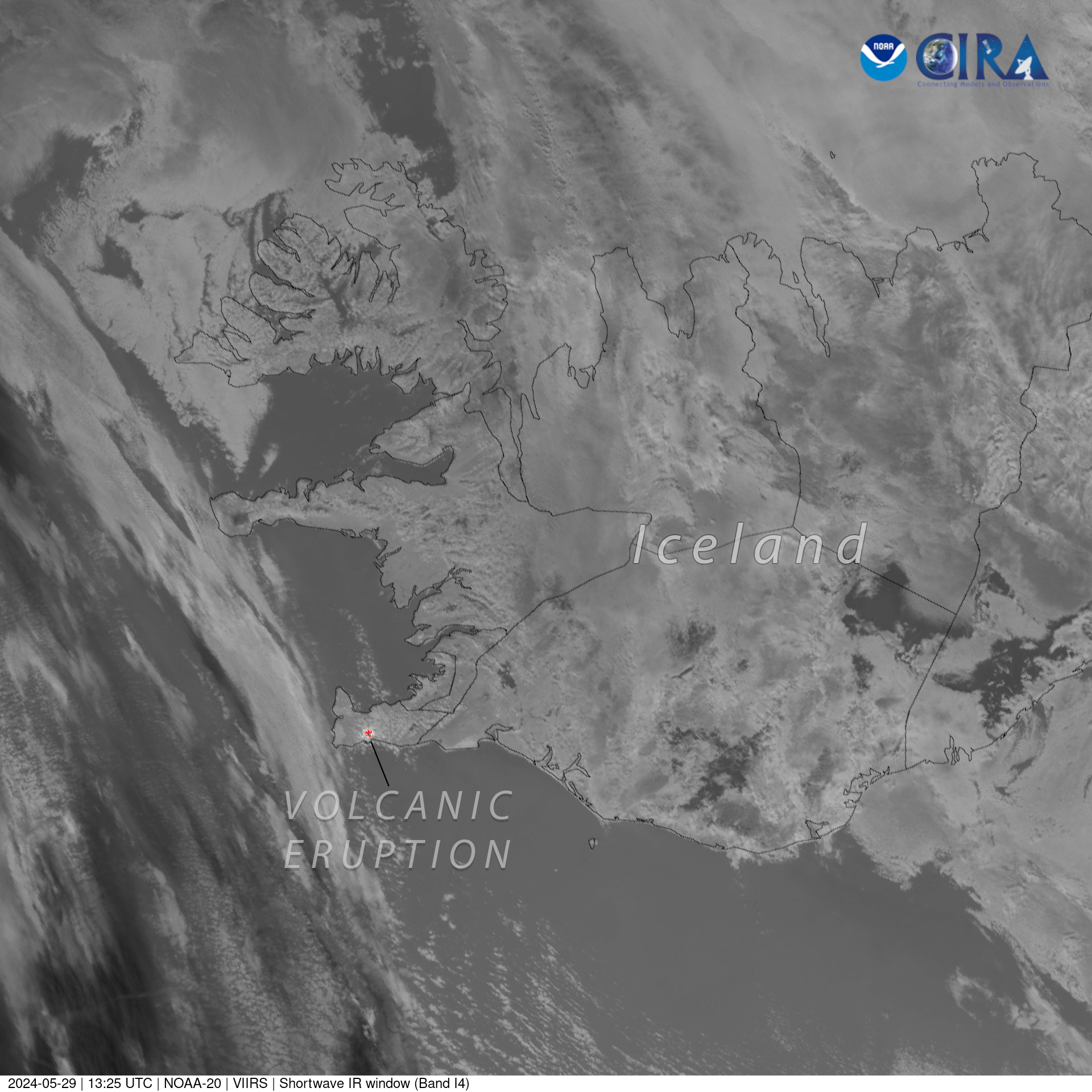
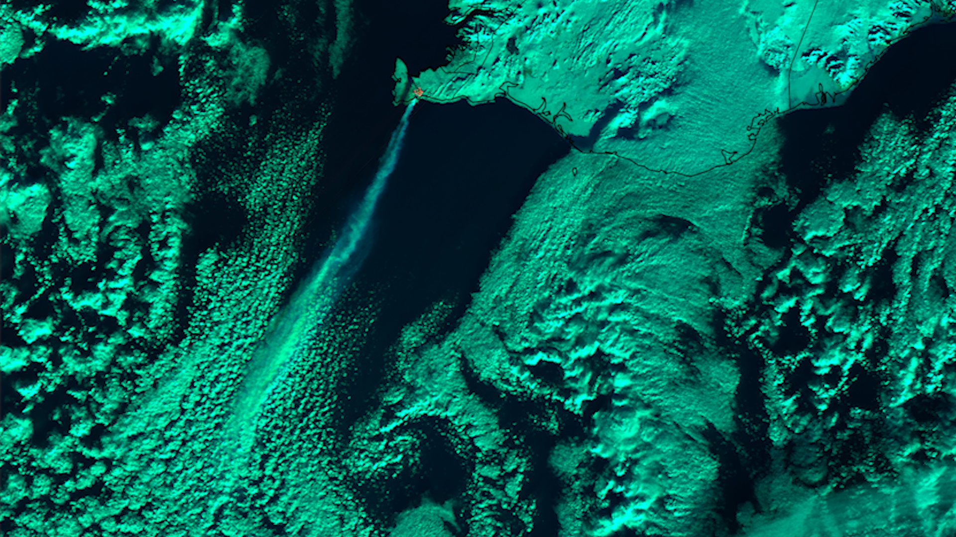
On May 29th, the volcano erupted for the fifth time, prompting the evacuation of the nearby Blue Lagoon geothermal spa. The eruption caused fountains of lava to shoot over a hundred feet in the air along a 2 mile (3.4 km) fissure.

For more information on the Icelandic volcanic system, visit the Catalogue of Icelandic Volcanoes.

|
Contributions by: Kim Erickson, Josh Reiter and Dakota Smith

Satellite imagery of this event:

Hover over the boxes to play. Click the images to view enlarged

Early June Activity on the Reykjanes Peninsula

Description:

Volcanic activity continues on Iceland’s Reykjanes peninsula from the May 29th eruption.


Phenomena: Volcanoes

Satellite: NOAA-20 NOAA-21 S-NPP

Product: Fire Temperature GeoColor

Instrument: VIIRS

Fiery Volcanic Eruption from Reykjanes Peninsula

Phenomena: Volcanoes

Satellite: NOAA-20 NOAA-21

Product: Fire Temperature

Instrument: VIIRS

New Volcanic Eruption Sends Lava Spewing out of the Ground

Description:

A fissure has opened up near Grindavik, Iceland, spewing lava onto the surface as a new volcanic eruption occured earlier this morning. The lava ejection from the eruption could be seen in high-resolution from NOAA-20.


Phenomena: Volcanoes

Satellite: NOAA-20

Product: Infrared (band I4)

Instrument: VIIRS

Cloud Free View of Reykjanes Peninsula with Ash Plume

Description:

Cloud free skies above the Reykjanes Peninsula of Iceland allowed polar-orbiting satellites the chance to capture a plume of ash and gases coming out of the volcanic fissures there.


Phenomena: Volcanoes

Satellite: NOAA-20 NOAA-21 S-NPP

Product: Ash (EUMETSAT)

Instrument: VIIRS

New Volcanic Eruption Lights up Despite Overcast Clouds

Description:

Overcast skies could not hide the newest volcanic eruption near the Icelandic town of Grindavik from polar-orbiting satellites. The onboard VIIRS instrument utilized the Day/Night Band product to catch this bright spectacle through the thick cloud layer.


Phenomena: Volcanoes

Satellite: NOAA-20 NOAA-21 S-NPP

Product: Day/Night Band

Instrument: VIIRS

Smoke Billows out of Volcanic Eruption Hotspot

Description:

Under clear skies over Iceland and the surrounding waters, polar-orbiting satellites got an unobstructed view of the volcanic eruption hotspot and smoke plume streaming from it.


Phenomena: Volcanoes

Satellite: NOAA-20 NOAA-21 S-NPP

Product: Day Fire

Instrument: VIIRS

Ash Plume From Lava Eruption

Description:

An ash plume from the volcanic eruption in Iceland extends far out from the fiery source, as captured by polar-orbiting satellites.


Phenomena: Volcanoes

Satellite: NOAA-20 NOAA-21 S-NPP

Product: Ash (EUMETSAT)

Instrument: VIIRS

Dual-View of Volcanic Eruption on Reykjanes Peninsula

Description:

The volcanic system on the Reykjanes Peninsula of Iceland erupted once again, witnessed from both the GOES-16 and Meteosat-10 geostationary satellites in this dual-view imagery.


Phenomena: Volcanoes

Satellite: GOES-16 Meteosat-10

Product: Day Fire

Instrument: ABI SEVIRI

Lava Impacts Icelandic Town of Grindavik

Description:

Iceland’s town of Grindavik was impacted by lava flows on Sunday. This imagery captured by polar orbiting satellites shows the hot spot created by the lava.


Phenomena: Volcanoes

Satellite: NOAA-20 NOAA-21 S-NPP

Product: Day Fire

Instrument: VIIRS

Opening Fissures Show Lava Hotspot

Description:

The ground opening its fiery maw near the Icelandic town of Grindavik was captured by VIIRS polar-orbiting satellites.


Phenomena: Volcanoes

Satellite: NOAA-20 NOAA-21 S-NPP

Product: Infrared (band I4)

Instrument: VIIRS

Thermal Signature Shows Volcanic Eruption near Grindavik, Iceland

Description:

The thermal signature of the volcanic eruption near Grindavik, Iceland. Imagery captured overnight by polar-orbiting satellites.


Phenomena: Volcanoes

Satellite: NOAA-20 NOAA-21 S-NPP

Product: Fire Detection (band M13)

Instrument: VIIRS

- January 16, 2024

See more Volcanoes events: