Hurricane Debby

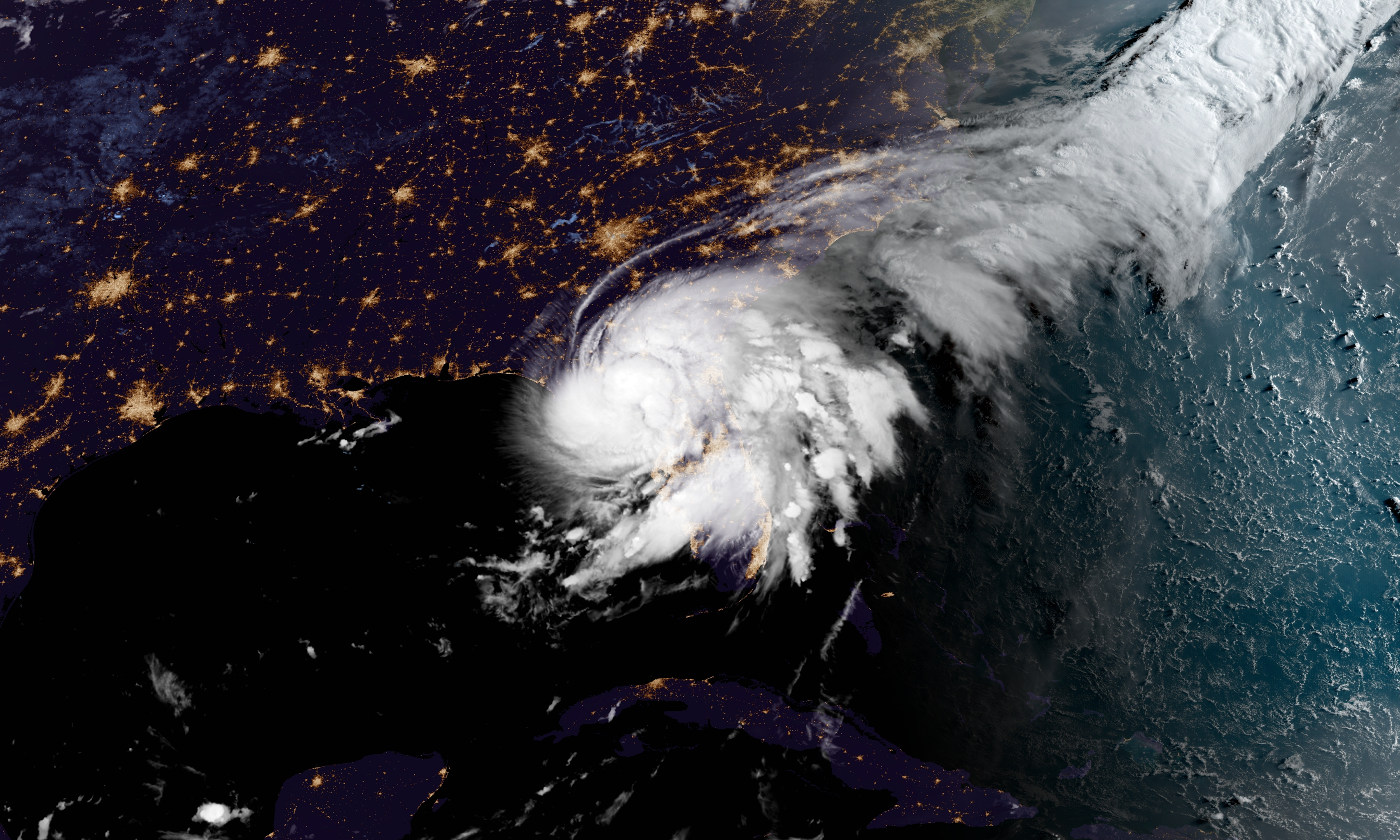
Debby formed as a tropical storm in the southeast Gulf of Mexico, just north of Cuba, on August 3rd, 2024.

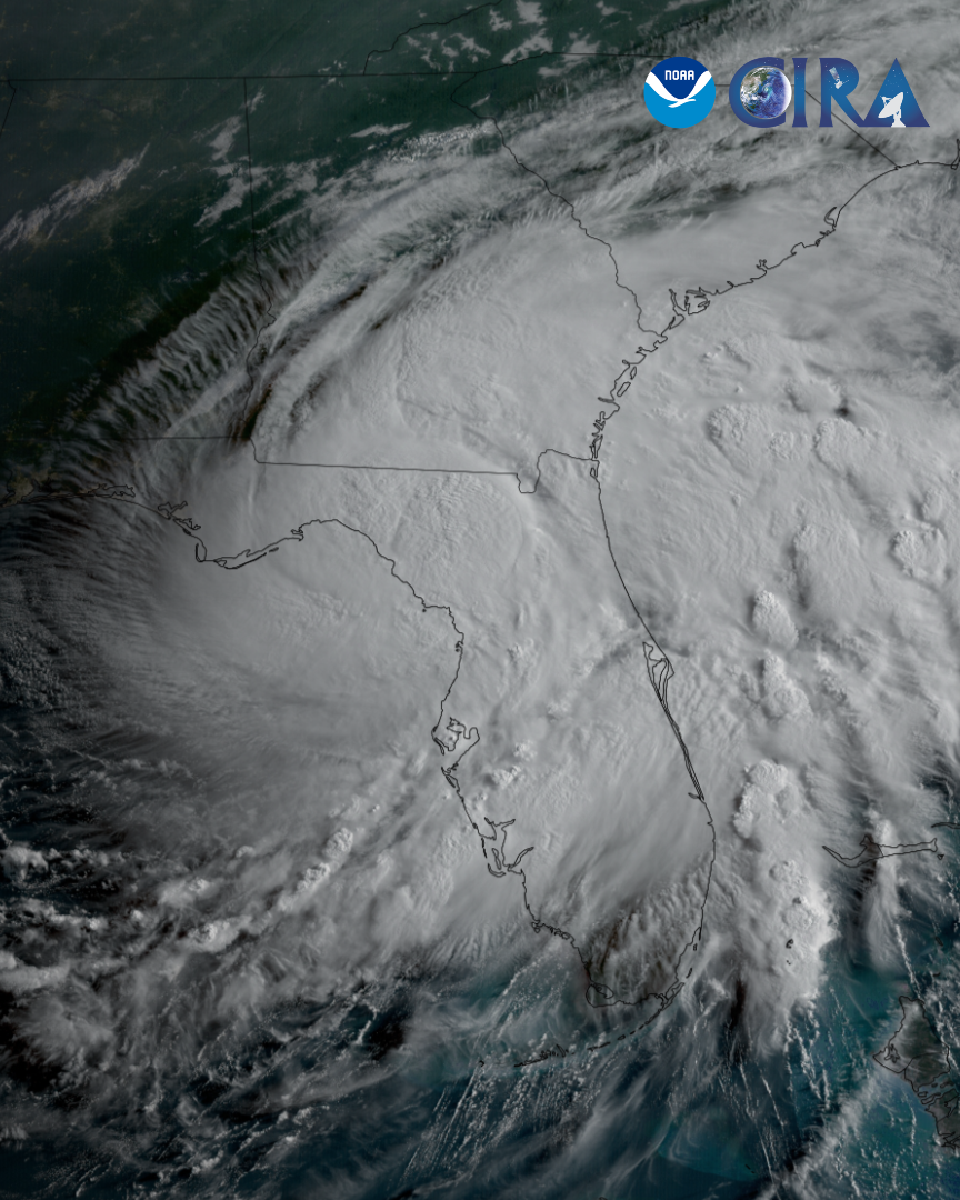
Debby was upgraded to hurricane status as it neared the state of Florida during the evening of August 4th, 2024.

Debby made landfall along the coast of Florida, in the Big Bend region of the state’s panhandle, as a category 1 hurricane on the morning of August 5th, 2024.

Hurricane Debby crossed Florida and Georgia, emerging back over the Atlantic Ocean as a tropical storm. It is forecast to bring heavy rainfall and flooding from Florida through the Carolinas and up into New England.

For more details and forecast information, visit the National Hurricane Center.

|
Contributions by: Josh Reiter, Dakota Smith and Kim Erickson

Satellite imagery of this event:

Hover over the boxes to play. Click the images to view enlarged

Hurricane Debby In-Depth

Description:

On August 5th, 2024, Hurricane Debby made landfall as a category one storm along Florida’s Big Bend region. (Image 1) Prior to landfall, Debby was fueled by the very warm waters of the Gulf of Mexico- surface temperatures averaged nearly 90°F (31°C) on August 1, 2024. (Image 2) This allowed the storm to dump at least six inches (38 cm) of rain over much of Florida, with some areas receiving over 15 inches (38 cm), leading to widespread flooding across the state. 


As Debby moved over northern Florida towards Georgia, the polar-orbiting satellite, S-NPP, snapped a high-resolution view of the storm in long-wave infrared light. The darker orange and reddish colors indicate the coldest cloud tops, which tell scientists where the strongest parts of the storm are located. (Image 3) 


After crossing Georgia, the storm spent a day over the Atlantic Ocean before turning northward and making landfall a second time on South Carolina’s central coast. Tropical Storm Debby brought nearly a foot (30 cm) of rain to much of South Carolina and southern North Carolina. Lightning energy density is overlayed on the GeoColor product, highlighting thunderstorm activity within the system. (Image 4) 


Phenomena: Tropical Cyclones

Satellite: GOES-16 S-NPP

Product: GeoColor GeoSST GLM Group Energy Density Infrared (band I5)

Instrument: ABI GLM VIIRS

Hurricane Debby’s Full, Impactful Journey

Description:

The full, impactful journey of Hurricane Debby. From the Caribbean through the Southeast U.S. to New England.


Phenomena: Tropical Cyclones Extratropical Transition Hurricanes

Satellite: GOES-16

Product: GeoColor

Instrument: ABI

Morning Sight of Tropical Storm Debby

Description:

The sun rises on Debby this morning as the tropical storm continues to traverse further inland. Severe weather, including a tornado threat, and heavy rainfall from Debby continues to pose a concern for the east coast of the US.


Phenomena: Tropical Cyclones

Satellite: GOES-16

Product: GeoColor GLM Group Energy Density Visible (band 2)

Instrument: ABI GLM

Tropical Storm Debby Brings Heavy Rain to the Mid-Atlantic

Description:

Tropical Storm Debby continues to bring heavy rain to the Mid-Atlantic states.


Phenomena: Tropical Cyclones

Satellite: GOES-16

Product: GeoColor GLM Group Energy Density

Instrument: ABI GLM

Sunrise on Tropical Storm Debby

Description:

The sun rises on Tropical Storm Debby as it continues to bring significant impacts to the Southeast US.


Phenomena: Tropical Cyclones

Satellite: GOES-16

Product: Visible (band 2)

Instrument: ABI

Day-Long Imagery of Debby Moving Across Florida

Description:

Day-long satellite imagery from today of Debby as the storm made landfall in Florida and moved across the northern part of the sunshine state.


Phenomena: Tropical Cyclones Hurricanes

Satellite: GOES-16

Product: GeoColor GLM Group Energy Density

Instrument: ABI GLM

VIIRS View of Debby Before Landfall

Description:

JPSS satellites caught a glimpse of Hurricane Debby just prior to it making landfall on the Florida Coast.


Phenomena: Tropical Cyclones Hurricanes

Satellite: NOAA-20 NOAA-21 S-NPP

Product: Infrared (band I5)

Instrument: VIIRS

Bubbling Convection as Debby Makes Landfall

Description:

The rising sun this morning over now Tropical Storm Debby shows the bubbling convection within as it moves over land. Over the next few days, Debby will pose a flooding threat to the Southeastern US due to heavy rainfall.


Phenomena: Tropical Cyclones Hurricanes

Satellite: GOES-16

Product: Infrared (band 13) Visible (band 2)

Instrument: ABI

High Resolution View of Debby's Landfall

Description:

A high resolution still view of Debby’s landfall.


Phenomena: Tropical Cyclones Hurricanes

Satellite: GOES-16

Product: GeoColor

Instrument: ABI

The First 48 Hours of Debby

Description:

The first 48 hours of Debby as it formed, moved through the Gulf of Mexico, and made landfall in Florida.


Phenomena: Lightning Tropical Cyclones Hurricanes

Satellite: GOES-16

Product: GeoColor GLM Group Energy Density

Instrument: ABI GLM

Sunrise on Hurricane Debby as it Pushes Inland

Description:

Sunrise on Hurricane Debby as the storm makes landfall and pushes inland.


Phenomena: Lightning Tropical Cyclones Hurricanes

Satellite: GOES-16

Product: GeoColor GLM Group Energy Density

Instrument: ABI GLM

Hurricane Debby Makes Landfall in Florida

Description:

Hurricane Debby has made landfall in the Big Bend region of the Florida Panhandle this morning.


Phenomena: Tropical Cyclones Hurricanes

Satellite: GOES-16

Product: Infrared (band 13)

Instrument: ABI

Hurricane Debby Nears the Florida Panhandle

Description:

Debby intensifies into a category 1 hurricane as it nears the coast of Florida. Hurricane Debby is forecasted to make landfall in the Florida panhandle on Monday morning.


Phenomena: Tropical Cyclones Hurricanes

Satellite: GOES-16

Product: GeoColor GLM Group Energy Density

Instrument: ABI GLM

Tropical Storm Debby Strengthens as it Approaches Florida

Description:

Tropical Storm Debby slowly strengthens as it approaches Florida.


Phenomena: Lightning Tropical Cyclones

Satellite: GOES-16

Product: GeoColor GLM Group Energy Density

Instrument: ABI GLM

Potential Tropical Cyclone Four Forms Near Cuba

Description:

Potential Tropical Cyclone Four forms over eastern Cuba. This system is forecasted to develop into a tropical storm this weekend, where it will bring heavy rainfall and isolated flooding to Florida and the Southeast US through early next week.


Phenomena: Tropical Cyclones

Satellite: GOES-16

Product: GeoColor GLM Group Energy Density

Instrument: ABI GLM

Invest 97L Moves Over the Greater Antilles

Description:

Invest 97L is a group of showers and thunderstorms moving across the Greater Antilles. This disturbance is forecasted to move into the vicinity of the eastern Gulf of Mexico and the Florida Peninsula at the end of this week.


Phenomena: Tropical Cyclones

Satellite: GOES-16

Product: GeoColor GLM Group Energy Density

Instrument: ABI GLM

Tropical Disturbance Being Monitored in the Central Atlantic

Description:

A tropical disturbance churns in the middle of two plumes of Saharan dust, just to the west of the Caribbean islands. This group of storms is forecasted to become more organized as it moves toward the Greater Antilles later this week.


Phenomena: Tropical Cyclones

Satellite: GOES-16

Product: GeoColor

Instrument: ABI

- July 29, 2024

See more Tropical Cyclones events: