Early May Severe Storms

Severe storms continue across the Plains and Midwest where large hail, damaging winds, and tornadoes are possible.

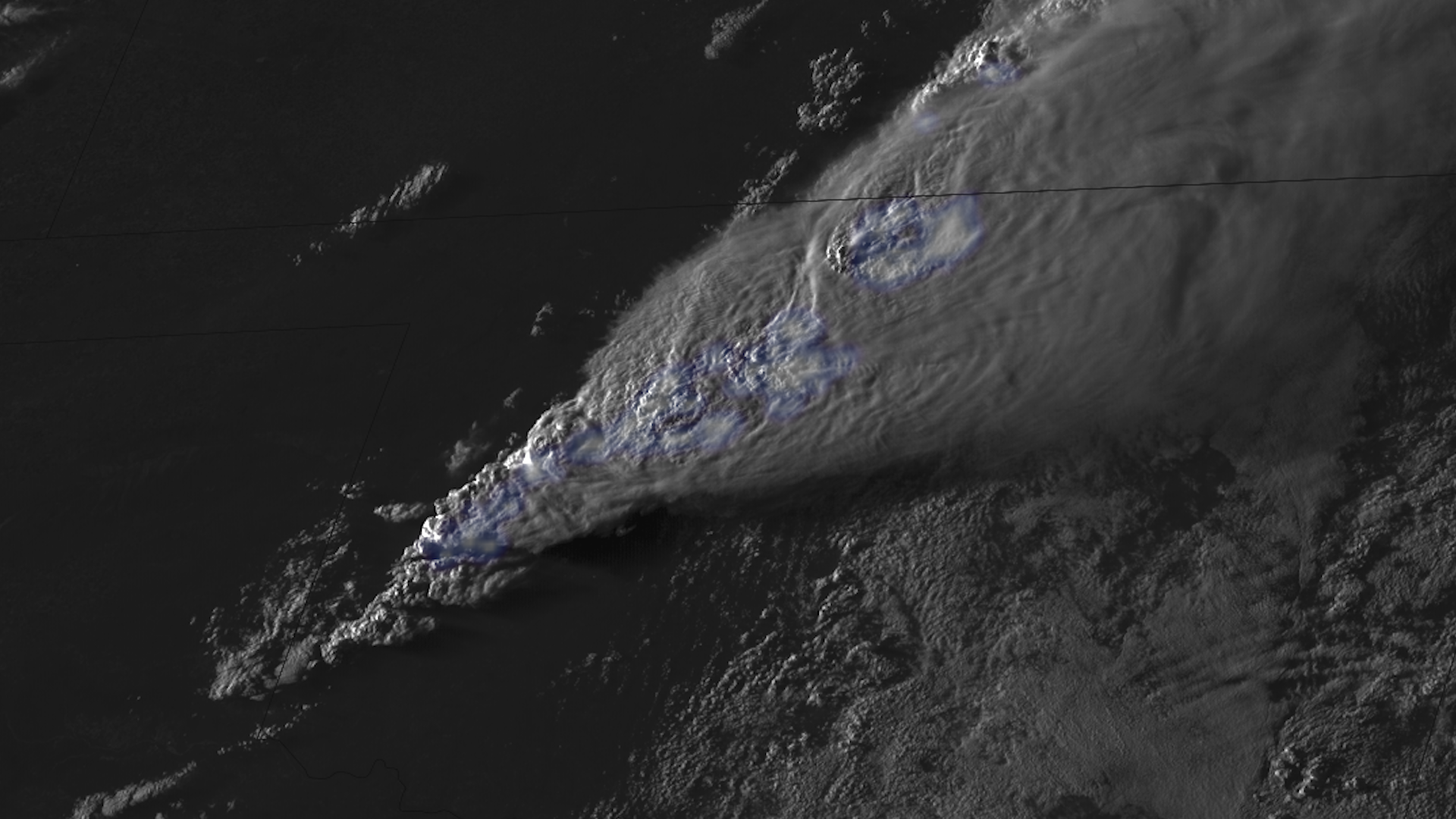
On May 7, 2024, severe storms raced across the Midwest. The storms spawned several damaging tornadoes in southern Michigan, including one that hit the town of Portage.

On May 6, 2024, a high risk of severe storms was issued for parts of Oklahoma and Kansas. During this high risk, a powerful, damaging tornado ripped through the towns of Bartlesville and Barnsdall in Oklahoma.

For more information, visit the Storm Prediction Center.

|
Contributions by: Kim Erickson, Josh Reiter and Dakota Smith

Satellite imagery of this event:

Hover over the boxes to play. Click the images to view enlarged

Active Night for Many Across the Southeast US

Description:

It was an active night for many folks across the southeastern US as multiple rounds of thunderstorms moved through the area.


Phenomena: Lightning Thunderstorms

Satellite: GOES-16

Product: GeoColor GLM Group Energy Density Infrared (band 13)

Instrument: ABI GLM

Storms Ignite Yet Again Across the South

Description:

Thunderstorms ignite across the Southern US yet again this afternoon. Satellites monitor storm activity as the severe weather threat continues through tonight, from Texas all the way to the Atlantic coast.


Phenomena: Thunderstorms

Satellite: GOES-16

Product: Infrared (band 13) Visible (band 2)

Instrument: ABI

Morning Storms Roll Across the Southeast

Description:

Thunderstorms continue to roll across the southeast US.


Phenomena: Thunderstorms

Satellite: GOES-16

Product: GLM Group Energy Density Visible (band 2)

Instrument: ABI GLM

Severe Storms Produce Tornadoes in Tennessee

Description:

Several ongoing severe thunderstorms have produced tornadoes across the state of Tennessee, including a large and dangerous tornado earlier this evening that tracked through Central Tennessee, near the city of Columbia. Tornado watches are still in effect across several Southern US states for the next few hours.


Phenomena: Thunderstorms Above Anvil Cirrus Plumes Tornadoes

Satellite: GOES-16

Product: Visible (band 2)

Instrument: ABI

Severe Weather Populates Across Mid-South and Midwest States

Description:

Numerous lightning strikes fill the skies above several Midwest and Mid-South states as severe weather continues to threaten the region this afternoon.

All severe storms hazards ranging from tornadoes, to large hail, to damaging wind gusts have been observed and will still be probable from the Ozarks to the Carolinas through tonight.


Phenomena: Lightning Thunderstorms

Satellite: GOES-16

Product: GeoColor GLM Group Energy Density Visible (band 2)

Instrument: ABI GLM

Sun Rises on a Supercell Over Missouri

Description:

The sun rises on a supercell thunderstorm traveling over Missouri. All severe storm hazards are possible today through the mid Mississippi, Ohio, and Tennessee Valleys.


Phenomena: Thunderstorms Overshooting Tops

Satellite: GOES-16

Product: GLM Group Energy Density Infrared (band 13) Visible (band 2)

Instrument: ABI GLM

Relentless Thunderstorms Hit Midwest and South

Description:

Thunderstorms relentlessly hitting parts of the Midwest and South.


Phenomena: Lightning Thunderstorms

Satellite: GOES-16

Product: GeoColor GLM Group Energy Density

Instrument: ABI GLM

Severe Storms Spawn Damaging Tornadoes in Southern Michigan

Description:

Severe storms racing across the Midwest, spawning several damaging tornadoes in southern Michigan.


Phenomena: Lightning Thunderstorms Hail Tornadoes Wind

Satellite: GOES-16

Product: GeoColor GLM Group Energy Density

Instrument: ABI GLM

Severe Storm Initiation Over the Midwest

Description:

Another round of severe weather has kicked off today as storms proliferate over the Midwest US. All storm hazards, including a few tornadoes, large hail, and strong winds are possible through the evening hours.


Phenomena: Lightning Thunderstorms

Satellite: GOES-16

Product: GLM Group Energy Density Visible (band 2)

Instrument: ABI GLM

Dangerous Tornado Touches Down in Northeast Oklahoma

Description:

A supercell in northeast Oklahoma produced a large and dangerous tornado that moved towards the towns of Barnsdall and Bartlesville. Storms continue to flare up across the Great Plains as the severe threat will last through the overnight hours.


Phenomena: Thunderstorms Tornadoes

Satellite: GOES-16

Product: GeoColor Infrared (band 13)

Instrument: ABI

Tornadic Storms Form in Oklahoma

Description:

Multiple tornadic storms erupt in Oklahoma.


Phenomena: Lightning Thunderstorms Tornadoes

Satellite: GOES-16

Product: GLM Group Energy Density Visible (band 2)

Instrument: ABI GLM

High-Risk Storms From Polar-Orbiting Satellites

Description:

This imagery taken from polar-orbiting satellites shows the storms on Monday afternoon, just after they first began firing-up across the Plains, and early Tuesday morning moving into the Midwest.


Phenomena: Lightning Thunderstorms

Satellite: NOAA-20 NOAA-21 S-NPP

Product: Day/Night Band Infrared (band I5)

Instrument: VIIRS

Lightning Indicates Strong Storm Development in the Plains

Description:

Strong and severe thunderstorms proliferate across the central and southern plains.


Phenomena: Lightning Thunderstorms

Satellite: GOES-16

Product: GLM Group Energy Density Visible (band 2)

Instrument: ABI GLM

Severe Thunderstorms Initiate in Oklahoma and Kansas

Description:

A line of storms have erupted along the frontal boundary in the central and southern plains, with some them already becoming severe. All severe storm hazards, including strong tornadoes, are forecasted for this region through the nighttime hours.


Phenomena: Thunderstorms

Satellite: GOES-16

Product: Visible (band 2)

Instrument: ABI

Storms Begin to Fire Up Over the Great Plains

Description:

Severe thunderstorms begin to fire up across the Great Plains.


Phenomena: Lightning Thunderstorms

Satellite: GOES-16

Product: GeoColor GLM Group Energy Density Visible (band 2)

Instrument: ABI GLM

See more Severe Storms events: