Western US Wildfires

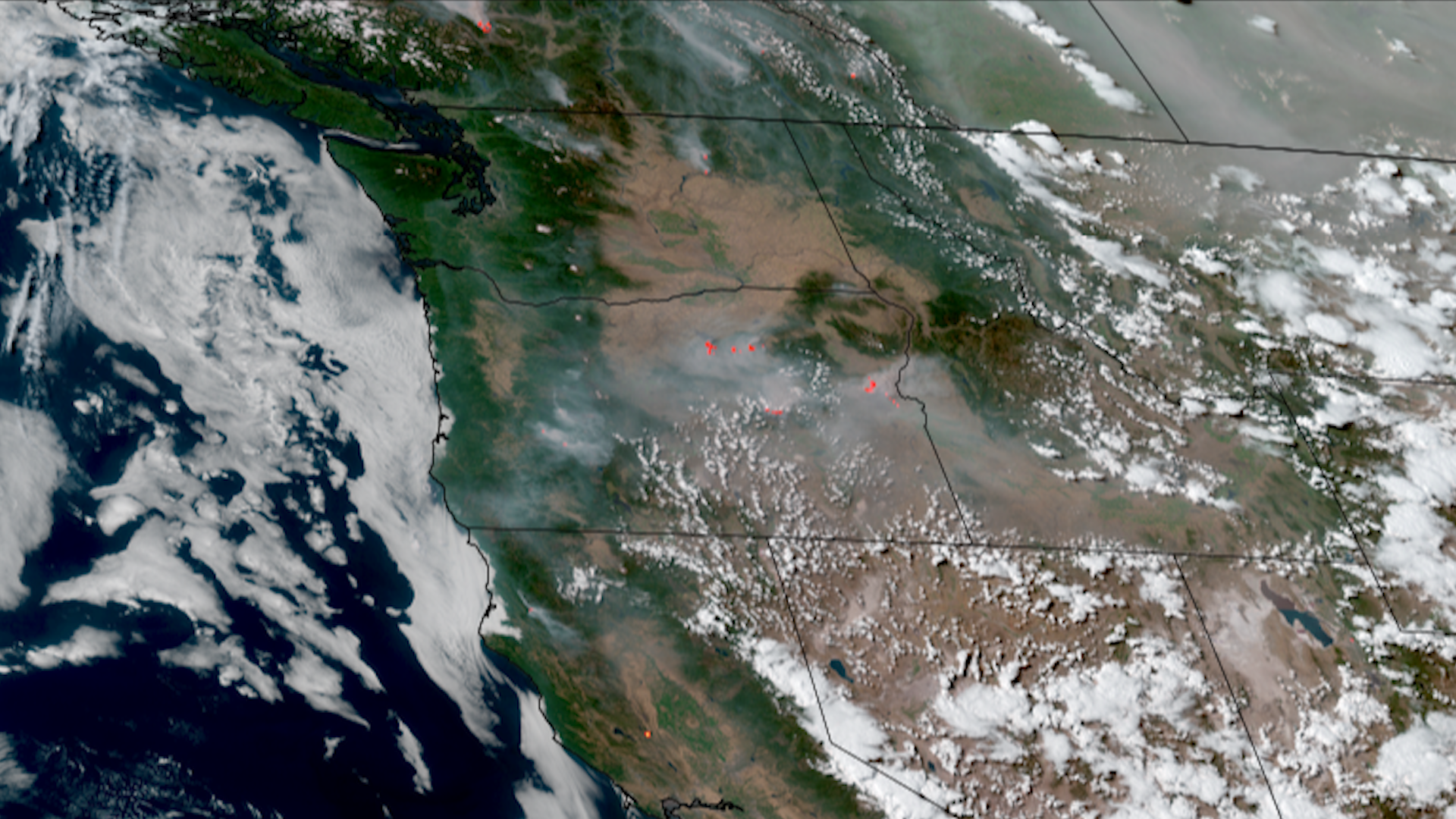
A hot and dry summer season in the Western US has lead to many fires spawning across multiple states. Hundreds of thousands of acres have been burned as wildfires rage from the Pacific Northwest down to the Desert Southwest.

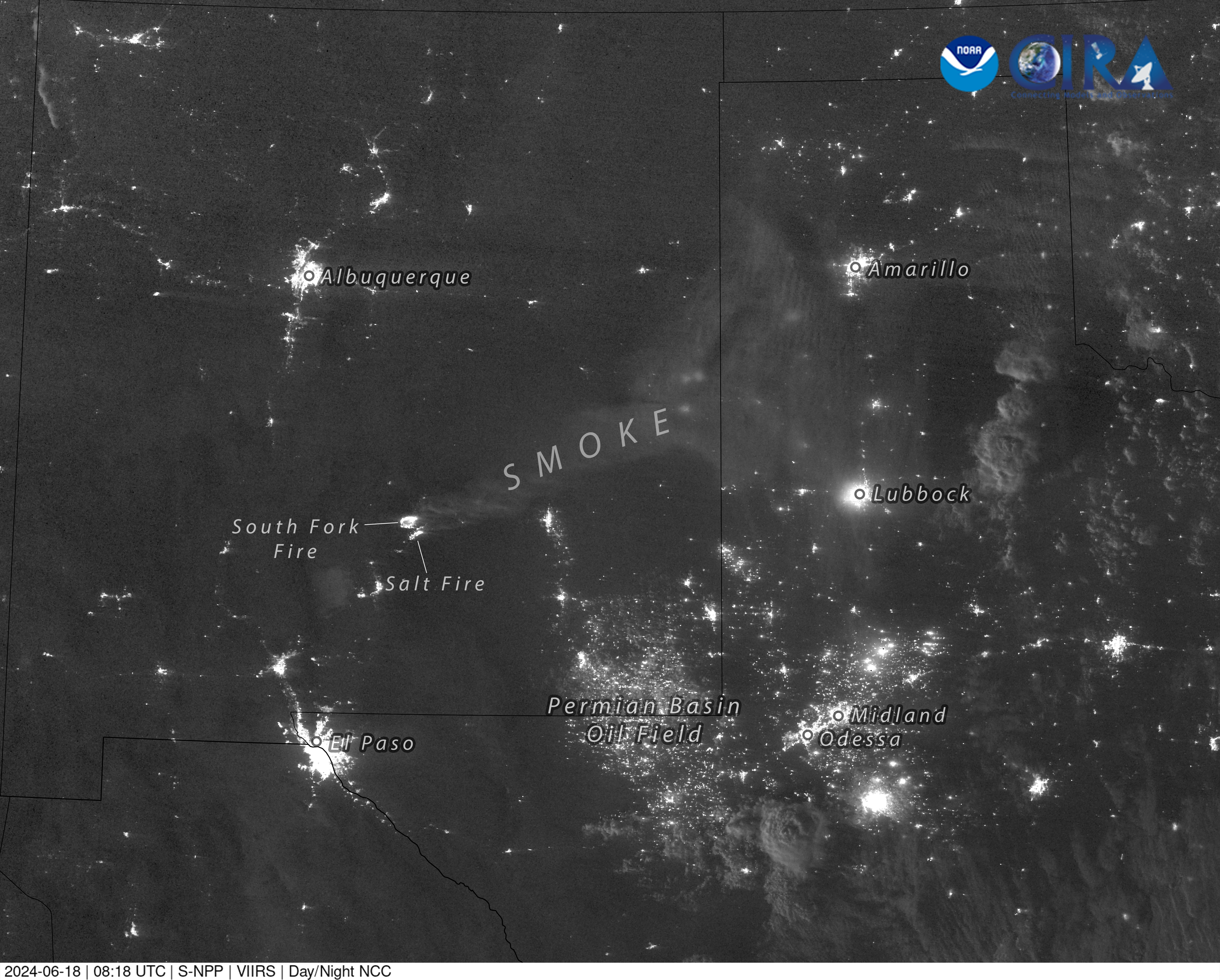
In New Mexico, several large and long-lived wildfires initiated during the months of May and June, including the Indios Fire, Blue 2 Fire, and the South Fork and Salt Fires. The burn scars left behind pose a flash flooding risk for nearby communities in New Mexico, especially as the Southwest monsoon season ramps up.

In the southern parts of Utah, wildfires like the Silver King Fire and Deer Spring Fire spread very rapidly under dry and windy conditions.

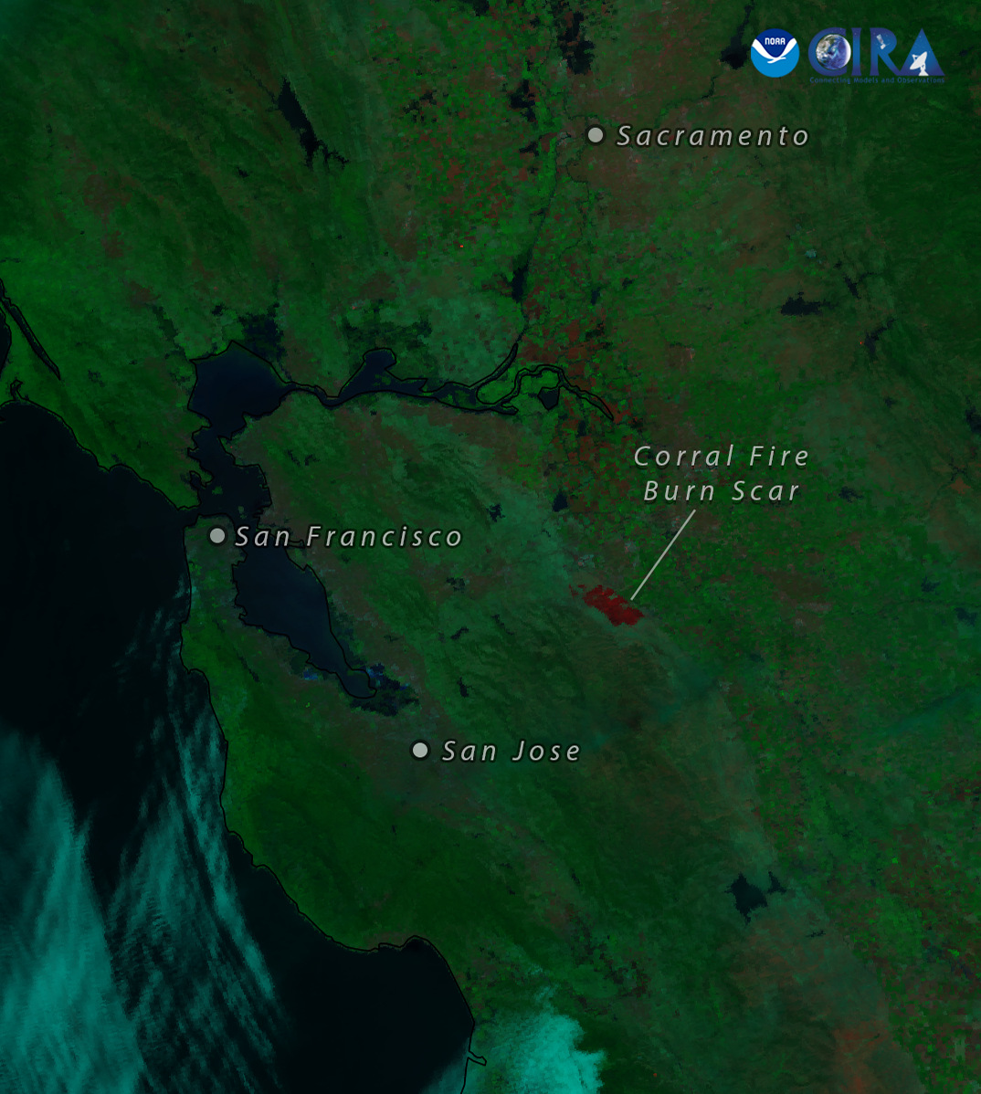
Even though summer is only just reaching the halfway mark, California has seen a pretty active fire season. Numerous hotspots have constantly plagued the Golden State over the last few months, with notable large wildfires like the Post Fire, Corral Fire, and Lake Fire situated not too far away from the state’s most populous cities.

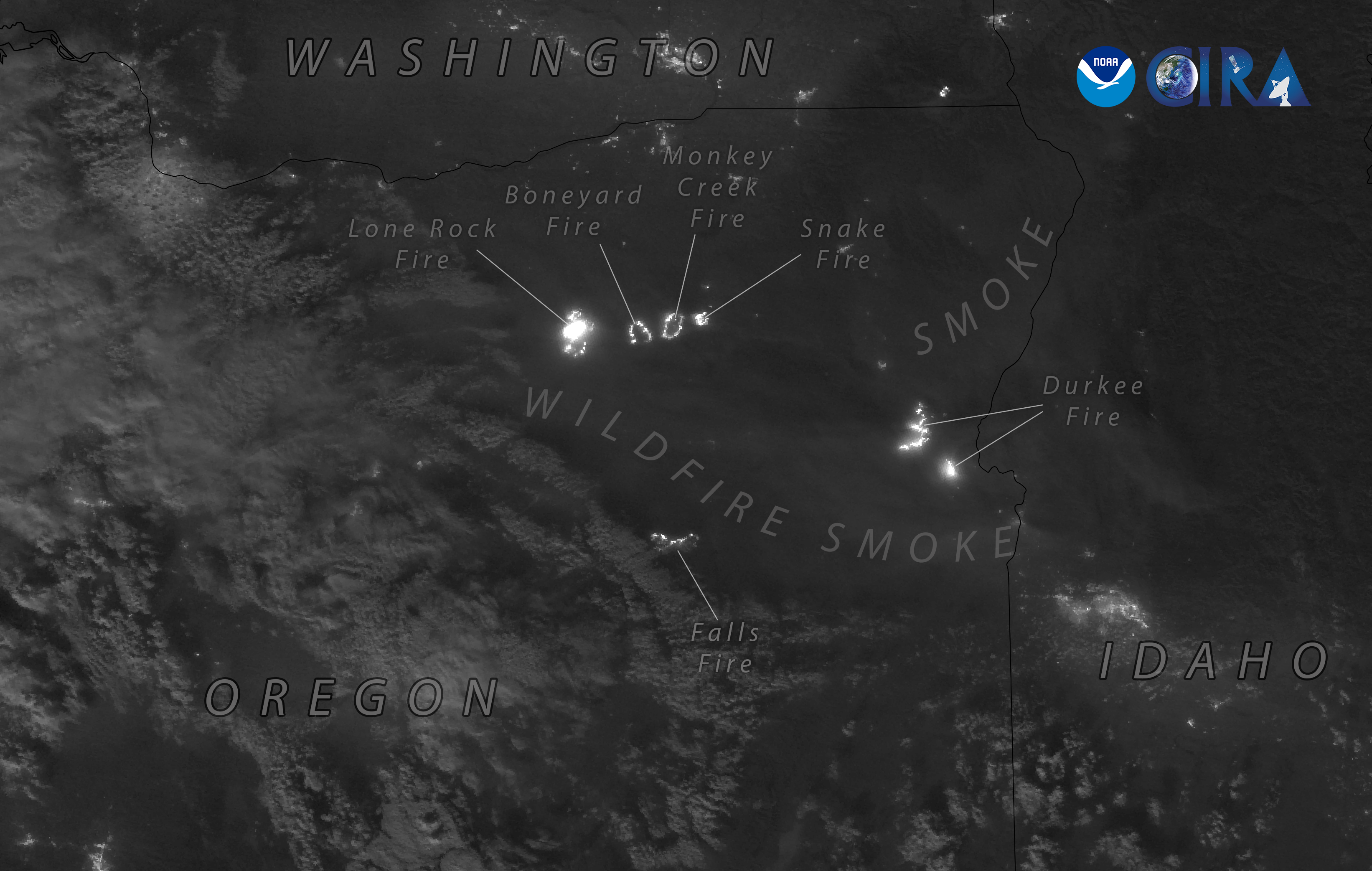
In July, a few fires exploded in size across the state of Oregon, with multiple swelling past 100,000 acres.

Combined with the fires raging in western Canada, smoke from the wildfires has draped across North America, creating hazy skies and air quality issues from hundreds of miles away.

|
Contributions by: Josh Reiter, Kim Erickson and Dakota Smith

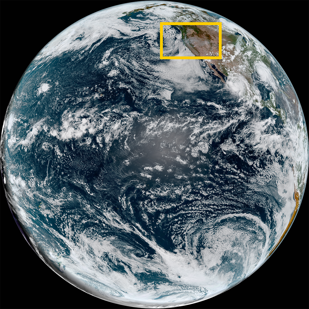
Satellite imagery of this event:

Hover over the boxes to play. Click the images to view enlarged

Smoke Across the United States From JPSS

Description:

Wildfire smoke continues to infiltrate across North America as JPSS satellites captured hazy skies above the central US this afternoon.


Phenomena: Wildfires Smoke

Satellite: NOAA-20 NOAA-21 S-NPP

Product: GeoColor

Instrument: VIIRS

Smoke Fills Skies over the United States

Description:

Much of the United States wakes up to incredibly smoky skies.


Phenomena: Wildfires Smoke

Satellite: GOES-18

Product: GeoColor

Instrument: ABI

Fires Across Oregon as Seen from Suomi-NPP

Description:

Suomi-NPP captured several large wildfires burning brightly in Oregon on early Sunday morning. Smoke from the fires was also observed, casting a haze that was illuminated by the flames below and the full moon above.


Phenomena: Wildfires Smoke

Satellite: S-NPP

Product: Day/Night Band

Instrument: VIIRS

Wildfires Populate the Western US

Description:

Wildfires burn strong throughout the western US and southwest Canada from this imagery from over the weekend, creating smokey skies for many across North America. In Oregon, several fires have exceeded 100,000 acres in size.


Phenomena: Wildfires Smoke

Satellite: GOES-18

Product: GeoFire

Instrument: ABI

Smoke Creates Hazy Conditions Across Canada and the US

Description:

As the sun rises across the US this morning, many locations are experiencing some level of haze as smoke drifts through the skies above, created by wildfires in western states and in portions of western Canada.


Phenomena: Wildfires Smoke

Satellite: GOES-18

Product: GeoColor

Instrument: ABI

JPSS Captures Growth of Falls Fire in Oregon

Description:

The Falls Fire in Oregon grew over 9,000 acres on July 15th, bringing to the total area to over 64,000 acres.


Phenomena: Wildfires Smoke

Satellite: NOAA-20 NOAA-21 S-NPP

Product: Day Fire

Instrument: VIIRS

Wildfires Blaze Across the Northwestern US

Description:

Wildfires blaze across the Northwestern US as temperatures remain hot across the region.


Phenomena: Wildfires Smoke

Satellite: GOES-18

Product: GeoFire

Instrument: ABI

Lake Fire Burns Near Santa Barbara

Description:

Over the weekend, a wildfire ignited in the hills of the Los Padres National Forest in Southern California, swelling to over 20,000 acres. JPSS satellites have been observing the growing burn scar and raging flames of the Lake Fire in the days since.


Phenomena: Wildfires Burn Scars

Satellite: NOAA-20 NOAA-21 S-NPP

Product: Day Fire

Instrument: VIIRS

Wildfires Explode in Southern Utah

Description:

The Silver King Fire and the Deer Springs Fire in southern Utah saw massive growth over the Fourth of July weekend, with both increasing to around 10,000 acres in size by Sunday night.


Phenomena: Wildfires Burn Scars Smoke

Satellite: NOAA-20 NOAA-21 S-NPP

Product: Fire Temperature GeoColor

Instrument: VIIRS

Multiple Wildfires Burn Across the Western US

Description:

Multiple wildfires burn across the Western US as temperatures across the region soar to record heights.


Phenomena: Wildfires

Satellite: GOES-18

Product: GeoFire

Instrument: ABI

Oak Ridge Fire Burns in Southern Colorado

Description:

Just southwest of Pueblo, Colorado, the Oak Ridge Fire has grown to over 1000 acres since its detection this past weekend. The VIIRS instrument onboard JPSS polar-orbiting satellites was able to detect the growing flames in the last few days.


Phenomena: Wildfires

Satellite: NOAA-20 NOAA-21 S-NPP

Product: Day Fire

Instrument: VIIRS

Foote Fire Burns as Storms Forms Over the South Fork and Salt Fires

Description:

The Foote Fire in eastern Arizona burns as thunderstorms build over the South Fork and Salt fires in southcentral New Mexico.


Phenomena: Thunderstorms Wildfires Smoke

Satellite: GOES-18

Product: GeoColor

Instrument: ABI

Wildfire Smoke Floats Near Severe Storms

Description:

Polar-orbiting satellites were able to capture the smoke as it lingered over the Central US, as well as the initial convection of the nearby line of thunderstorms.


Phenomena: Thunderstorms Wildfires Smoke

Satellite: NOAA-20 NOAA-21 S-NPP

Product: GeoColor

Instrument: VIIRS

Smoke From Wildfires Drift Across Central US

Description:

Smoke from the wildfires in New Mexico drifted into the wind flow of an upper-level trough today, floating across the Great Plains. Severe thunderstorms initiated close by in the afternoon along the leading edge of a cold front.


Phenomena: Thunderstorms Wildfires Smoke

Satellite: GOES-16

Product: GeoColor

Instrument: ABI

South Fork and Salt Fires Burn at Night in Central New Mexico

Description:

The South Fork Fire and Salt Fire in central New Mexico have both erupted in size since yesterday, releasing large smoke plumes into the atmosphere. Suomi-NPP was able to utilize the Day/Night band last night to capture the bright burning hotspots of the fires, as well as the smoke plume illuminated by moonlight.


Phenomena: Wildfires Smoke

Satellite: S-NPP

Product: Day/Night Band

Instrument: VIIRS

Post Fire Burns Northwest of Los Angeles

Description:

Over the last 48 hours, the Post Fire exploded to over 15,000 acres in the Hungry Valley Park, located in Southern California northwest of Los Angeles. Smoke from the fire can be seen in this imagery from VIIRS polar-orbiting satellites yesterday drifting down towards the second most populous city in the US.


Phenomena: Wildfires Burn Scars Smoke

Satellite: NOAA-20 NOAA-21 S-NPP

Product: Fire Temperature True Color RGB

Instrument: VIIRS

Pyrocumulus Cloud Expelled From Post Fire

Description:

A pyrocumulus cloud is expelled from the newly burning Post Fire northwest of Los Angeles.


Phenomena: Wildfires Pyrocumulus

Satellite: GOES-18

Product: GeoColor

Instrument: ABI

Corral Fire Burn Scar Seen From NOAA-21

Description:

Fueled by dry, warm air and gusty winds, the Corral Fire, which began burning in Northern California on Saturday, grew to a size of over 14,000 acres by the end of the weekend. Yesterday afternoon, NOAA-21 was able to get a clear view of the burn scar left behind by the flames.


Phenomena: Wildfires Burn Scars

Satellite: NOAA-21

Product: Day Fire

Instrument: VIIRS

Blue 2 Fire in New Mexico Under a Full Moon

Phenomena: Wildfires Smoke

Satellite: NOAA-20 NOAA-21 S-NPP

Product: Day/Night Band

Instrument: VIIRS

Multi-Day Timelapse of Indios Wildfire

Description:

Back on May 19, lightning ignited the Indios Fire in the Chama River Canyon Wilderness of northern New Mexico. This imagery shows the evolution of the wildfire over the last few weeks, taken in high-resolution from JPSS satellites as it expanded to over 11,000 acres.


Phenomena: Wildfires Burn Scars

Satellite: NOAA-21

Product: Day Fire

Instrument: VIIRS

- June 18, 2024

See more Fires events: